OS1/15/35/25


| List of names as written | Various modes of spelling | Authorities for spelling | Situation | Description remarks |
|---|---|---|---|---|
| DUNBAR [Parish] | Ph. [Parish] of Dunbar Ph. [Parish] of Dunbar Ph. [Parish] of Dunbar |
Stat Acct [Statistical Account] (1841) Full. [Fullertons] Gazeteer Map of Co. [County] (1799) |
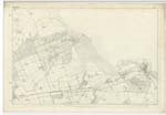
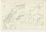
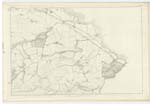
006 ; 007 ; 011 ; 012 | [Situation] In the Eastern part of the Co. [County] A parish consisting of a Royal burgh and a landward district, the former is near the Castle to which it owes both its name and existence. The latter Stretches along the Coast from East to W. [West] nearly 8 miles, and from S. [South] to north nearly 3 miles. It is bounded by the parishes of Tynningham and PrestonKirk on the west, Stenton and Spott on the South, Innerwick on the east and the German Ocean on the north. A detached portion of the parish called Dunbar outer common consisting of about 7 square miles is separated from the parish by the intervention of the parishes of Spott and Stenton, being bounded by those parishes on the north, by Spott and Innerwick on the east, by the detached portions of Spott and Stenton in the south, and by Whittingham on the south and west. The detached portion is quite a moorland district lying upon the Lammermoors. The main body is generally all throughout well enclosed and cultivated. The Royal burgh of this parish is the seat of a Presbytery in the Synod of Lothian and Tweeddale. |
Continued entries/extra info
[Page] 25Parish of Dunbar
Transcribers who have contributed to this page.
DANIALSAN, Stuart Johnston
Location information for this page.