OS1/15/33/57


| List of names as written | Various modes of spelling | Authorities for spelling | Situation | Description remarks |
|---|---|---|---|---|
| PRESTONKIRK | Parish of PrestonKirK Parish of PrestonKirK Parish of PrestonKirK Parish of PrestonKirK Parish of PrestonKirK |
Forrests Map Johnston's Map Fullarton's Gazetter New Stat: Acct [Statistical Account] Oliver & Boyd's Almanac |
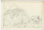
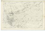
006 ; 010 | [Situation] N.E. [North East] from the centre of the County A parish in Haddingtonshire a litle north east of the centre of the County. It is bounded on the north by North BerwicK; on the east by WhiteKirK and Dunbar; on the south by Stenton, Whittingham and Norham; & on the west by Haddington, Direlton, and Athelstaneford. In the Southern extremity of this parish, a conspicuous conical hill, called Traprain Law, rises to the height of About 700 feet.From near the north base of this hill a curved dell of great depth, carries down a rill to the Tyne. All the rest of the Surface is but softly through agreeably varied with undulation and gentle swell, and is for the most part arable. The farm steadings in this parish are of Superior Construction, And the farms in [continued on page 58] |
Continued entries/extra info
[Page] 57Parish of PrestonKirk
Form 136
Transcribers who have contributed to this page.
Bizzy- Moderator, Chr1smac -Moderator
Location information for this page.