OS1/15/31/17


| List of names as written | Various modes of spelling | Authorities for spelling | Situation | Description remarks |
|---|---|---|---|---|
| Supposed site of BATTLE (9th Century) | Site of Battle Site of Battle |
William Stevin James Douglas |
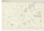
005 | [Situation] About 1 1/4 Mile East from New Mains A portion of ground on which a battle was fought in 815 betwixt the scots and saxons. The latter were defeated, intheir flight their Commander Athelstane was killed by an archer when crossing the Cogtail Burn a short distance above the farm house of Athelstane New Mains. The ground is marked by 2 upright stones about 3 feet high, one of which on the N. [North] side the other at the Southern extremity. |
Continued entries/extra info
[Page] 17Parish of Atholestaneford
Form 136 Page
55 Supposed site of the Battle
Supposed site of the Battle [Notes]
The ford where tradition points out as the place
where Athelstan was slain is shewn on trace and on plan
and the term "Ford" written with a further explanation
"Where Athelstan was slain (supposed)"
"History records
that the lands on which the battle of Athelstane was fought an won
were given by the King of Scots to the Culdee Priory of St. Andrews
as an acknowledgment of gratitude to Heaven for the victory obtained."
See Stat Acct [Statistical Account] (1841) for farther description see forms 136.
See also Sinclair's Stat. Acct vol. [Statistical Account volume] 10 p. [page] 161.
"This is correct - It is
not - Site of Battle
(9th Century)
(Supposed) - That would
make the whole a mere
supposition - The same rule applies to
Remains of Pict Houses (Supposed) on page 13 - It should be Remains of supposed Picts Houses" OMO [Ordnance Mapping Office]
Transcribers who have contributed to this page.
Trondragirl- Moderator, Ian Anderson
Location information for this page.
Linked mapsheets.