OS1/15/27/65


| List of names as written | Various modes of spelling | Authorities for spelling | Situation | Description remarks |
|---|---|---|---|---|
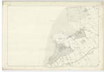
| GREEN CRAIG | Green Craig Green Craig |
Thomas Christison Gosford James Armstrong Aberlady |
004 | A small Island Situated within the tide-mark on the fore-shore off the farm of Craigylaw, its Surface consists of R.P. [Rough Pasture] and on it is a Trignl [Trigonometrical] Station called by Trig [Trigonometrical] Party "Greencraig". Its Surface is covered by every ordinary Spring tide and it is bounded by flat broken rocks and it is the property of the Earl of Wemyss. |
| PEFFER BURN | Peffer Burn Peffer Burn |
Thomas Christison Gosford Mr Lambe Aberlady Lodge County Map by Johnstone. |
004 | A Small river rising on the farm of Waughton & flowing in a Westerly direction by the farms of Congalton and Muirton, falls into Aberlady Bay near Luffness, its Channel Stream sweeps round the headland of Aberlady Point on the foreshore and joins the Low Water Mark at Gosford Sands. |
Continued entries/extra info
[Page] 65List of Names collected by Thomas Smith C. Asst. [Civilian Assistant]
Plan 4 B Trace 4.
Parish of Aberlady
Object
Green Craig - A Rock
Peffer Burn - A River
[Signed] Thomas Smith CA. [Civilian Assistant]
Transcribers who have contributed to this page.
Chr1smac -Moderator, Ian Anderson
Location information for this page.
Linked mapsheets.