OS1/15/25/103


| List of names as written | Various modes of spelling | Authorities for spelling | Situation | Description remarks |
|---|---|---|---|---|
| NORTH BERWICK LAW | North Berwick Law North Berwick Law North Berwick Law |
Forrest's County Map 1799 Greenwood & Co's [Company's] Co. [County] Map. 1825 Statistical account |
002 | A very beautiful, Conical Hill about 940 feet above the level of the Sea, and about 800 feet above its base, - stands on an elevated plain, and is of Comparatively easy ascent; the Various Views in ascending, and particularly from its Summit, both inland & seaward, are of the most delightful and commanding character. The Ruins on the top are only of modern date, and were the residence of a party, consisting of a Naval officer and three Assistants, - in Charge of a Signal station established thereon during the late war, and dismantled on the Return of Peace. The Law is ascended from the East by a prepared Zig-zag path Called from its form the M-walK; its surface is, towards the Summit, Covered with Rocks - not precipitous, but elevated above its sloping surface. |
| MILL BURN | Mill Burn Mill Burn Mill Burn |
Statistical Acct. [Account] Mr James Hislop Mr H. Wallace |
002 | A Small stream which flows in a N.E. [North East] direction passing the W. [West] & North base of North Berwick Law, thence to Lochbridge Toll Bar, where it takes a Northerly direction to the Sea. It bears the name from the Junction of two small streams near N. B. [North Berwick] Law to the sea. |
Continued entries/extra info
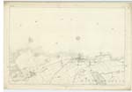
[Page] 103Plan 2C -- Parish of North Berwick
Transcribers who have contributed to this page.
Moira L- Moderator, Ian Anderson
Location information for this page.
Linked mapsheets.