OS1/15/4/10


| List of names as written | Various modes of spelling | Authorities for spelling | Situation | Description remarks |
|---|---|---|---|---|
| STONEFOLD RIG | Stonefold Rig Stonefold Rig Stonefold Rig |
Mr. Blair James Davidson Co. [County] map 1799 |
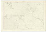
016 | [Situation] About 2 1/2 Miles N. [North] West from Bothwell A small eminence of a ridge like shape on the farm of Millknowe. Its surface consists of heathy pasture. |
| LAMMERMUIR HILLS | Lammermuir Hills | See Name Bk [Book] 19 B | 016 | For descriptive remarks see Name List for Plan 19 B. |
| BELTON DOD | Belton Dod Belton Dod Dod |
James Davidson Mr. Blair Forrests Co. [County] map |
016 | [Situation] About 3 Miles N.W. by N. [North West by North] from Bothwell A small hill on the farm of Beltondod. Its surface consists of heathy pasture. On it is a Trig. [Trigonometrical] Station called by Trig. [Trigonometrical] party "Bently dod" |
Continued entries/extra info
[Page] 10Parish of Spott
Form 136 Page
58 Stonefold Rig
48 Belton Dod
Transcribers who have contributed to this page.
Nellie- Moderator, Douglas Montgomery
Location information for this page.
Linked mapsheets.