OS1/10/50/125


| List of names as written | Various modes of spelling | Authorities for spelling | Situation | Description remarks |
|---|---|---|---|---|
| DUB'S CALDRON | Dub's Cauldron | Rev[Reverend] George Wight John Charters Parish Schoolmaster Alexander French Webster's Topographical Dictionary of Scotland |
025 | Is immediately below the Pan, the water here falls about 6 feet between two rocks, the pool below is deep, and presents a sheet of foam, this is the principal of the three. |
| KIRK BURN | Kirk Burn Kirk Burn Kirk Burn |
David Rogerson farmer Mr Carruthers farmer Samuel Rogerson farmer |
025 | A small stream, begins its name in the South extremity of Sauchie Banks at this point there is a small stream where the name changes from Steffenbigging burn to Kirkburn, Kirkburn runs into Wamphray Water at Wamphray Mill, near the Parish Church. |
| WAMPHRAY MILL (Corn) | Wamphray Mill (Corn) | Rev[Reverend] George Wight Dabvid Rogerson Esq[Esquire] Leithenhall Samuel Rogerson Leithenhall |
025 | A meal mill, with dwelling house, stabling, garden etc [Is situated on the Wamphray Water, at the Parish Church, this is the only Mill in the Parish] Timber does be cut there but there is no shed or building to mark as a Saw Mill |
Continued entries/extra info
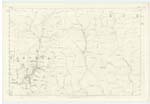
125 Parish of Wamphray Sheet 25.13 Trace 2Dubs Cauldron situation In Wamphray Water
Wamphray Mill situation 5 Chains North West from Church
Kirk Burn situation From the junction of Leithknowe Sike and Staffenbigging Burn North West to Wamphray Water.
M Donohue 1st May 1857
John Jane Sapper Royal Engineers
Transcribers who have contributed to this page.
stellas
Location information for this page.
Linked mapsheets.