OS1/10/48/5


| List of names as written | Various modes of spelling | Authorities for spelling | Situation | Description remarks |
|---|---|---|---|---|
| HARE SIKE | Hare Syke Hare Syke Hare Syke |
John Common (Farmer Richard Common (Farmer John Boyes (Shepherd |
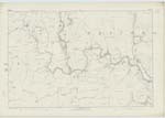
035 | [Situation] On Nn. [Northern] Parish Boundary. A Rivulet which rises on Plea Moss and forms the Boundary between the Parishes of Tundergarth and Westerkirk to its Confluence with the Water of Milk. |
| PLEA MOSS | Plea Moss Plea Moss Plea Moss |
John Common (Farmer Richard Common (Farmer John Boyes (Shepherd |
035 | [Situation] On Nn. [Northern] Parish Boundary. An extensive morass at the eastern extrimity of this Parish. |
| PLEAMOSS HILL | Pleamoss Hill Pleamoss Hill Pleamoss Hill |
John Common (Farmer) Richard Common Farmer) John Boyes (Shepherd) |
035 | [Situation] 1/4 mile S. [South] from Plea Moss. A Considerable hill near the east side of this Parish |
Continued entries/extra info
[Page] 5Parish of Tundergarth -- Plan 35.15 Trace 1
[Signed] Philip Munro
Lce Corpl R.E. [Lance Corporal Royal Engineers]
Transcribers who have contributed to this page.
CorrieBuidhe- Moderator, Brenda Pollock
Location information for this page.
Linked mapsheets.