OS1/10/47/1


| List of names as written | Various modes of spelling | Authorities for spelling | Situation | Description remarks |
|---|---|---|---|---|
| TORTHORWALD [parish] | Torthorwald Torthorwald Torthorwald |
Walkers Map of Scotland Crawford's Map of Dumfriesshire Johnstone's Map of Dumfriesshire |
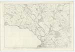
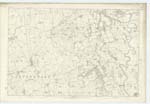
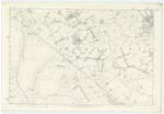
049; 050; 056 | [Situation] In the S.Wn. [South Western] district of the County of Dumfries. The Name of this Parish is generally supposed to signify "The Castle or Tower of Thor in the Wood." As it might somewhat perplex Antiquarian research satisfactorily to account for the introduction here of the god Thor, probably the first Etymon is merely a repetition, - the Name being compounded of Anglo-Saxon Tor, a tower and Walda or Wealt a wooded district. There yet exist remains of a very Ancient Stronghold and it has been Ascertained beyond All doubt that the greater part of this Parish was in an early Age covered with Oakwood. Torthorwald, a parish in the debateable district between Lower Nithsdale and Lower Annandale - having no detached portion within the boundaries of another Parish nor within its limits a detached part of Any other Parish - is bounded on the West by Dumfries Parish, on the North West and West by Tinwald, on the East by Lochmaben And Mouswald. on the South-East by Mouswald and on the South-West by Carlaverock and Dumfries. The Boundaries between it and those of Lochmaben And Tinwald are but indifferently defined by ditches, dikes and small tributary Streams which separate also the lands of Conterminous proprietors. - Wath Burn, a tributary of Lochar Water - separating it from Mouswald traces the Eastern boundary, - the Western boundary is Strongly defined along the whole line of March by Lochar Water dividing it from Dumfries Parish. This Parish lies on the SW [South West] Side of a gently Sloping ridge the Summit of which 650 feet in height Constitutes the March between two divisions of the County of Dumfries - Nithsdale and Annandale. Its Shape is pretty Compact - approaching somewhat near to a Square were it not for one long point which projects three Miles beyond the rest towards the South - the extreme length from North to South is 6½ miles and extreme breadth 3¼ miles - the Area as P [Per] Statistics is 5,600 Acres classified |
Continued entries/extra info
[Page] 1Parish of Tortherwald Co. [County] Dumfries
Transcribers who have contributed to this page.
DANIALSAN, lowlandscot
Location information for this page.