OS1/10/42/1


| List of names as written | Various modes of spelling | Authorities for spelling | Situation | Description remarks |
|---|---|---|---|---|
| PENPONT [parish] | Penpont | Walkers' Map of Scotland Crawford's Map of Dumfriesshire Johnston's Map of Dumfriesshire |
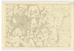
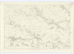
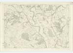
012; 013; 020; 021 ;022; 030; 031 | The name of the parish is supposed to have been derived from a hanging bridge (pendens pons), believed to have been constructed by the Romans across Scar water, and which structure - on the Site of the existing Scar Bridge - was in use up to the year 1801. A more ingenious etymology and one perhaps more worthy of credit from its association with the aborigenes and characteristic features of the district is from the Celtic Ben or Ben high - and Pont a sharp crag. - Accordingly Glenquargen or Glenwhargen Crag at the Northern extremity of parish, - Giving several other heights in the neighbourhood descriptive of this interpretation, - presents itself to the South and South-West a bold and precipitous front of about 800 feet and which may with some propriety be acknowledged the particular object from which this Parish derives its name,- more especially when considered, that the district must have had a name anterior to the Roman entrance thereto.- The Parish of Penpont is bounded on the North by those of Sanquhar and Durisdeer, on the East by Morton and Closeburn, on the South by Keir and Tynron and on the West by Dalry in Kirkcudbrightshire.- There is no detached portion within the boundaries of another parish, nor is there within its limits as described by the foregoing adjacent Parishes a detached part of any other Parish.- Its shape is irregular - in extreme length from N.W [North West] to S.E. [South East] it is 14 miles and in average breadth nearly 2 and 2/3 miles.- Its area has been heretofore computed & Statistics etc. at 32½ Square miles or 20, 914 Impl. [Imperial] Acres.- The correct Area however has been found to exceed 22,000 Acres.- This Parish may be divided into two divisions; the upper which may contain about 2/3 of the entire Area is almost entirely pastoral, the lower division is for the most part arable.- Natural Wood is interspersed throughout the entire district, the Lr. [Lower] division is embellished with thriving plantations connected with those on the Drum-=lanrig Estate.- Only about 1/8 of the entire parish is cultivated.- There are about 40 farms which consist for the most part of Sheep pasture.- Farm Steadings are of the most commodious and sub=stantial description, the lands are well enclosed and protected and altogether, this district may be considered as steadily advancing in agricultural improvement. The upper division is diversified there with numerous hills which attain an altitude of from 500 to 1000 feet of which Glenwhangen, at the Northern extremity, may be considered the most prominent.- Towards the N.En. [North Eastern] district there is a bare hill of gradual ascent, which terminates in that of Cairnkinna 2,080 above sea level.- The Parish is watered by numerous Streams, the most considerable of which are the Nith, Scar Water, Chanlock |
Continued entries/extra info
1Parish of Penpont
County of Dumfries
Transcriber's notes
Part of the right edge of this page is missing or turned away from the scanner, but for the most part this is of little consequence. The word(s) after Ben-high, Glenwhagen and presents are the most obscure.Transcribers who have contributed to this page.
John Dunlop
Location information for this page.
Linked mapsheets.