OS1/10/41/47


| List of names as written | Various modes of spelling | Authorities for spelling | Situation | Description remarks |
|---|---|---|---|---|
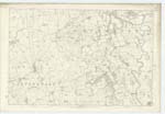
| WATH BURN | Wath Burn Wath Burn Wath Burn |
John Tweedie Post office Mouswald David Carr Mouswald William Irvin Townfoot, |
050; 056 | [Situation] Tracing Wn. [Western] Parish Boundary A large stream flowing in a southerly direction through this Plan, it forms the boundary between Torthorwald Ph. [Parish] & Mouswald, It also forms the boundary between Nithsdale and Annandale |
| LOCHAR MOSS | Lochar Moss Lochar Moss Lochar Moss | John Tweedie David Carr William Irvin |
056 | [Situation] Forming S.wn. [South western] Section of Parish A large tract of moss on the Southern side of this Plan |
| IRONHIRST MOSS | Ironhirst Moss Ironhirst Moss Ironhirst Moss Ironhirst Moss Ironhirst Moss |
John Tweedie David Carr William Irvin Thomas Caruthers [Carruthers] John Hall |
056 | [Situation] At S.wn. [South western] extremity of Parish A large tract of moss situated on the farm of Ironhirst (hence the name |
| MOUSWALD BURN | Mouswald Burn Mouswald Burn Mouswald Burn Mouswald Burn Mouswald Burn |
John Tweedie David Carr William Irvin See Authorities Page Report [-] Smeaton on drainage of Lochar Moss |
056 | [Situation] Running in a S.wn. [South western] direction through Parish A large stream flowing in a westerly direction through this Plan, Commences in Dalton Parish & falls into Black Grain, near Horseholm. |
Continued entries/extra info
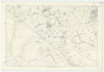
[Page] 47Parish of Mouswald -- Plan 56/10 Trace 1
[Signed] Samuel S Hill
Lce. Corpl RS&m [Lance Corporal Royal Sappers & Miners]
Transcriber's notes
Ironhirst Moss - Descriptive Remarks - the 'h' in Ironhirst seems to be split/abnormal so that it looks like 'Ironl urst'Mouswald Burn - Authorities - unknown abbreviation [see OS1/10/5/11: "Report by J. Smeaton on the drainage of Lochar Moss"]
Transcribers who have contributed to this page.
mac1
Location information for this page.