OS1/10/39/65


| List of names as written | Various modes of spelling | Authorities for spelling | Situation | Description remarks |
|---|---|---|---|---|
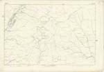
| CRAIGIEBURN HILL | Craigiyburn Hill Craigyburn Craigyburn From Craigy-Rocky |
Mr William Johnstone CraigieBurn James Patterson CraigieBurn John Renwick Selcoth Johnston's County Map Crawford's Map Dr. [Doctor] Jamiesons Sc: [Scottish] Dicty Dictionary |
017 | [Situation] About 3/4 mile S.W. [South West] by South from Shortwoodend Hill A Hill on Craigieburn Farm |
| CRAIGIEBURN WOOD | Craigyburn Wood Craigyburn Craigyburn |
Mr William Johnstone CraigieBurn James Patterson CraigieBurn John Renwick Selcoth Johnston's County Map Crawfords Map |
017 | [Situation] At the S.E. [South East] side of Craigyburn Hill A large Wood extending along the face of Craigieburn Hill, the wood mostly Forest Trees and Underwood |
| CONNEL BECK | Connel Beck | Mr William Johnstone CraigieBurn James Patterson CraigieBurn John Renwick Selcoth Peter Johnstone Esqr. Auldton |
017 | [Situation] North of Craigyburn Hill A Burn having its source on Craigyburn Hill running through the wood it falls into Moffat Water. |
Continued entries/extra info
[Page] 65 -- Parish of Moffat -- Sheet 17.1 Trace 4[Signed] J G Andrew
S[Sapper] R.E[Royal Engineers]
Transcribers who have contributed to this page.
Chr1smac -Moderator, stellas
Location information for this page.
Linked mapsheets.