OS1/10/38/23


| List of names as written | Various modes of spelling | Authorities for spelling | Situation | Description remarks |
|---|---|---|---|---|
| LOCH SKEEN | [Loch Skene] Loch Skeen |
Robt[Robert]Johnstone John Braidfoot William Brown Fullarton's G[Gazeteer] of Scotland Websters Topo[Topographical] Dictionary Statistical Acct[Account] of the Psh[Parish] |
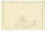
004 | A loch on the farm of Polmoodie surrounded on three sides by steep precipitous hills. it is sometimes written Loch Skene |
| MIDLAW BURN | [Moodlaw Burn] Midlaw Burn |
Robt[Robert]Johnstone Polmoodie John Braidfoot Birkhill William Brown Birkhill |
004 | A stream rising on Donalds Edge and falling into Tail Burn. |
| TAIL BURN | [Greymarestail Burn] Tail Burn Tail Burn Tail Burn Loch Skeen Burn |
Robt[Robert]Johnstone John Braidfoot William Brown History of Moffat Fullartons Gazeteer of Scotland |
004 | A rapid stream flowing out of Loch Skene and falling into Moffat Water, on which there is a celebrated Waterfall called the Grey Mare's Tail. Tail Burn is the name known. Grey Mare's Tail burn not known. |
| UPPER TURNBERRY | 004 |
Continued entries/extra info
Page 23 Parish of Moffat Plan 4-15 Trace 1Midlaw Burn situation From the East side of Donald's Edge South East to Greymarestail Burn.
Loch Skeen situation At the North Eastern extremity of Dumfriesshire
Tail Burn situation From the South East extremity of Loch Skeen South East to Moffat Water
No entry for Upper Turnberry
W Paterson C/a
Transcribers who have contributed to this page.
stellas
Location information for this page.
Linked mapsheets.