OS1/10/27/1


| List of names as written | Various modes of spelling | Authorities for spelling | Situation | Description remarks |
|---|---|---|---|---|
| HUTTON AND CORRIE | Hutton and Corrie | Crawford's Map of Dumfries-shire Blackwood's Map of Dumfries-shire Johnston's Map of Dumfries-shire |
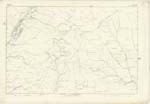
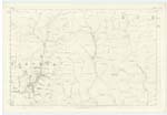
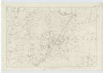
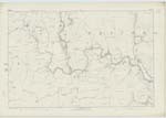
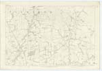
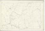
017; 025; 034; 035; 036; 043; 044 | [Situation] In the N.En [North Eastern] division of the County of Dumfries. The Name of this Parish is composed of those of two old Parishes annexed in 1609. Hutton may be compounded either of Holt a wood (pronounced haut) and tun a dwelling or Hut and tun - the town of huts - Anglo Saxon. Corrie is derived from that of a Stream in the district, which again takes its appellation from a deep glen where it rises - such glens having been called by the Scoto-Irish Coire - a cauldron. The Parish of Hutton-and-Corrie is bounded on the North by that of Moffat on the East by Eskdalemuir, Westerkirk and Tundergarth, on the South by Tundergarth and on the West by Dryfesdale, Applegarth and Wamphray. There is no detached part of Hutton-and-Corrie within the boundaries of another Parish nor is there within the limits above assigned to it a detached portion of any other Parish. It commences on the North in a point and gradually acquires a breadth of 3 1/2 miles at the middle, it afterwards contracts to 2 1/2 and again suddenly expands to 5 1/2 miles, and from thence contracts regularly to its Southern extremity to 2 1/2 miles. It measures 13 3/4 miles in length and has an average breadth of about 3 miles. Its entire Area has hitherto been considered to be 23000 acres. [Continued on page 2] |
Continued entries/extra info
[Page] 1Parish of Hutton & Corrie -- County of Dumfries.
Transcribers who have contributed to this page.
CorrieBuidhe- Moderator, mikeh
Location information for this page.
Linked mapsheets.