OS1/10/19/10


| List of names as written | Various modes of spelling | Authorities for spelling | Situation | Description remarks |
|---|---|---|---|---|
| BLUE CAIRN HILL | Blue Cairn Hill | John Beattie, Dalgleish. Archibald Glendinning, Glendearg |
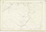
011 | [Situation] About 1/2 Mile East of Blaeberry Edge A considerable hill to the north of Pentland hill, over which the boundary separating the Counties of Selkirk and Dumfries, runs. It is mostly covered with rough pasture, and is situated on the farms of Dalgleish and Glendearg. There is a Trigonometrical Station on its highest point called Blue Cairn |
Continued entries/extra info
[Page] 10Parish of Eskdalemuir.
Sheet 11. No. 13. Trace 3
Transcribers who have contributed to this page.
CorrieBuidhe- Moderator, VickiColeman
Location information for this page.
Linked mapsheets.