OS1/10/10/2


| List of names as written | Various modes of spelling | Authorities for spelling | Situation | Description remarks |
|---|---|---|---|---|
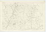
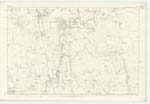
| ROMAN CAMP [Camp Dyke] | 051 | |||
| ROMAN ROAD [Dryfesdale parish] | 043; 051 | |||
| Site of BATTLE between Julius Agricola and Corbredus Galdus | 051 |
Continued entries/extra info
2, Parish of Dryfesdale, Co. [County] DumfriesMarket Town of much importance (See Page 75,_ It consists principally of one Street running from North to South a distance of 55 chains, flanked on either side by [ ] detached buildings. The central portion is called High Street, in which are principal buildings [Inns] etc. for the most part two and three storeys high.. The Nn. [Northern] and Sn. [Southern] extremities are respectively called Townhead and Townfoot almost the whole of the houses in which are only one storey high.. Near the centre of the High Street a line extends 18 chains East which [is] called Bridge St. the houses in which are also only one storey high._ The houses are in good repair, which together with the small gardens respectively attached, give to this village the appearance of a neat, tidy, compact and flourishing Town._ (see Page 75 for farther particulars.) _ There is within this Parish one Established Church, erected 1751, two Parochia[l] Schools, an United Presbyterian Church and one Free Church - all situated in the town of Lockerbie._ Population about 2,300._
The Roman Road from Carlisle via Birrenswark as shewn on Genl. [General] Roy's map of Lower Annandale and as describ[ed] by various authorities entered this Parish at Blackford on the Eastern Boundary about 1/2 mile S.E. of Lockerbie _ traversed N. N. W. to a point distant about 3/4 mile N. N. [ ] from Lockerbie Market Cross, whence describing a curve it directed its course West passing about 3/4 mile to the North of Dryfesdale Gate where two lines diverged N. and W. respect[ively] by Gallaberry Hill in this Parish towards Clydesdale - and to the confluence of Kinnel Water and River Annan towards Nithsdale- Another line branching off from near the a[s] mentioned point led to Agricola's Camp across Torwood Muir._ Information cannot be obtained in the district to warrant a delineation on Plan of the entire track or even, f[ ] what is shewn thereon has been drawn from local authority after a careful measurement and comparison with Roy's Map and the descriptions of other authorities._ Mr. Dobie of Ladyward an aged but intelligent person - resident in district from childhood - is thereby enabled to speak precisely of the Roman Road both from tradition and recollection of visible track thereof._ That portion shewn as forming the Turnpike Road from Lockerbie to the great Carlisle highway is generally believed in locality to have originated with the Roman Road and which m[ay] be confirmed from accounts by statistical and other authority._The site shewn to the East thereof has been pointed out as the Track existing in Mr. Dobie's young days,_ he recollects when two large posts stood on each side thereof at which a toll was gathered . This obstacle was the cause of much complaint in the district, those who were so [multed] asserting that Turnpike Trustees were not de jure entitled to such a Tax as the road then existing was actually a bona fide Roman Road._ The supposed site sh[own] as leading from the main line across Torwood Muir to Agricola's Camp is pointed out by Mr. Dobie to the best of his knowledge as the reputed Track existing prior to improvements of the land._
Several Camps and Forts are to be met with throughout this Parish. _ Among the former the most conspicuous _ set about 1/4 of a mile West from the town of Lockerbie on Torwood Muir _ is pronounced by Genl. [General] Roy and other Antiquarian Authorities to be a camp of Julius Agricola. _ Prop[iti]ated with figure 4 in Genl. [General] Roy's illustrations of single and double Consular Camps it would thereby appear to have been constructed for a single legion with allies. _ Nearly the whole of west side of this work can still be traced on the ground and which from Roy's Map would seem to be the only vestiges existing even at the period of the antiquarian's research._ The Name - Vernacular - "Camp Dyke may to some extent be confirmatory of the origin of these remains._ More modern antiquarians have (perhaps theoretically) pronounced a Camp - situate 1/2 mile N.N.W. at Dryfesdale Gate to be British and to have formed a counterpart to the foregoing, attrib[ute] thereby, the intervening ground to be the Scene of a bloody conflict between Julius Agricola's forces and those of Corbredus Galdus 21st. King of the Scots.- This Camp covering a space of upwards of two acres, seems from vestiges at its Southern extremity to have had triple lines of entrenchment._ A small Camp 1/4 mile S.E. of Agricola's Ca[mp] is well defined particularly on the East side also by triple lines of entrenchment and may reasonably be characterized as an Outpost of that work._An isolated [continued on next page]
Transcriber's notes
Some words on the far right of the image have not been fully captured in the scanned image. Suggested missing letters are indicated within [ ] brackets.A list of names is not present on the image, only a continuation of the description remarks for Dryfesdale that commenced on the previous page.
Transcribers who have contributed to this page.
mikeh
Location information for this page.