OS1/10/6/81


| List of names as written | Various modes of spelling | Authorities for spelling | Situation | Description remarks |
|---|---|---|---|---|
| CAMPLE WATER | Cample Water Cample Water |
Peter Mc Morrin Shepherd Midtown John Douglas William Mitchel Townhead |
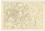
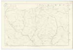
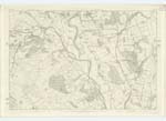
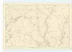
022; 023; 031; 032 | [Situation] Tracing Western Parish Boundary A stream that takes is rise in the Parish of Morton and flows in a South West direction nearly along the Boundary of Morton and Closeburn. It then takes a westerly direction and falls into the River Nith |
| SANDRUM | Sandrum Sandrum Sandrum Sundrum Sandrum High Sandrum |
John Johnstone Mrs Hunter John Stoba Valuation Roll 1856 Property Map Particulars of Sale of Closeburn Estate |
022 | [Situation] 1/4 mile N. [North] from Newton neat cottage and garden the property of the Trustees of William Baird and occupied by Mrs. Hunter |
| NEWTON HIGH QUARRY | Newton High Quarry (Sandstone) Newton High Quarry (Sandstone) Newton High Quarry (Sandstone) |
John Johnstone George Jardine John Stoba |
022 | [Situation] 1/4 mile N. [North from Newton A sandstone quarry situated on the farm of Newton |
Continued entries/extra info
Parish of Closeburn No. 21. Plan 22/16 Trace 1[Page] 81
Transcribers who have contributed to this page.
Chr1smac -Moderator, Lockside
Location information for this page.