OS1/10/4/86


| List of names as written | Various modes of spelling | Authorities for spelling | Situation | Description remarks |
|---|---|---|---|---|
| BROOMIEKNOWE | Broomieknowe Broomieknowe Broomieknowe Broomy Know |
James Telfer Broomieknowe John Armstrong Greenburn William Patterson Barrascroft Johnston's Map |
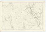
053 | [Situation] On the East bank of Byre Burn. Two farm houses with outhouses gardens and farm of land attached occupied by James Telfer & Robert Elliot, Proprietor, Duke of Buccleuch The same name applies to a house 7 chains north of this clump of buildings - on Sheet 53 No 4 Trace 6. |
| GREENBURN | Greenburn Greenburn Greenburn |
James Telfer Bromieknowe John Armstrong Greenburn William Patterson Barrascroft |
053 | [Situation] About 13 chains S.W.W. [South West West] from Broomyknowe. A farm house, with outhouses garden and farm of land attached occupied by John Armstrong, Proprietor Duke of Buccleuch |
| HOOK SIKE | Hook Syke Hook Syke Hook Syke |
William Patterson Barrascroft John Armstrong Greenburn James Telfer Bromieknowe |
053; 054 | [Situation] From the west of Over Barrascroft S.W. [South West] to Byre Burn. A stream which has 'its' source a little North of Orchard. it runs a considerable way and falls into Byre Burn near Byreburn Bridge |
| GREY STANE | Grey Stane Grey Stane |
Edward Calvert, Farmer Orchard Robert Davidson, Flesher Claygate |
053 | [Situation] About 1/4 mile N.E.E. [North East East] from Broomyknowe. A large granite rock on the farm of Orchard, in a field to the west of the farm house. |
Continued entries/extra info
[Page] 86,Parish of Canonbie -- Plan 53.8 -- Trace 3
[Entry for Dark Wood below Greenburn not included in Index] -- Dark Wood
[Authorities] James Scott Merchant, Claygate
John Armstrong, Greenburn
[Situation] On the West bank of Byre Burn.
[Description] A small wood extending from Byreburn Bridge, in a northerly direction, along the western bank of Byre Burn; for about 25 chains.
[Signed] Michael Henigan
Transcribers who have contributed to this page.
Moira L- Moderator, georgelaidlaw
Location information for this page.