OS1/10/3/113


| List of names as written | Various modes of spelling | Authorities for spelling | Situation | Description remarks |
|---|---|---|---|---|
| MARY'S CLEUCH | Mary's Cleugh Mary's Cleugh Mary's Cleugh |
Mr. Davidson (Grieve) Balgray. Thomas Davidson Balgray Hill. Mr. Hope, Farmer Rockhillflat |
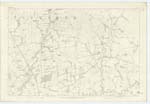
043 | [Situation] On Sn. [Southern] Parish Boundary A small stream and Glen running along and forming in part, the Southern boundary of the Parish. It enters Dryfe Water 10 Chains South of Lammonbie Bridge |
| FORT [Nether Cleuchhead] | Fort Fort Camp |
Mr. Davidson. Balgray Thomas Davidson, Balgray Hill Old Estate Map_ |
043 | [Situation] 26 chains S,S,E, [South, South, East,] from Balgray House An entrenchment of an oval form, lying between Mary's Cleugh, and Cleugh heads Burn,. On the East side there are two Banks, about 5 feet in height, with a ditch on the outside of the Banks, _ On the West side, one bank only, from which the natural fall of the ground is very rapid_ The Fort is in pretty good preservation |
Continued entries/extra info
[Page] 113Parish of Applegarth. -- Sheet 43. No. 6_ Trace 4
[Signature] James A. Emslie
Transcribers who have contributed to this page.
ruthmcd
Location information for this page.
Linked mapsheets.