OS1/5/27/1


| List of names as written | Various modes of spelling | Authorities for spelling | Situation | Description remarks |
|---|---|---|---|---|
| LANGTON | Langton (Parish) | New Statistical Account of Berwickshire -- Fullerton's Gazetteer of Scotland Chalmers Caledonia Map of Berwickshire |
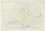
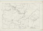
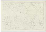
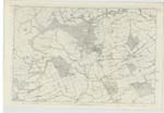
009 ; 010 ; 015 ; 016 | Langton a Parish in the centre of Berwickshire, lying partly in the Merse and partly among the Lammermoor hills; and bounded on the north by Longformacus on the north east by Dunse and Edrom; on the south by Edrom and Polwarth; and on the west by Longformacus. It is nearly triangular, but with sinuous outline, and measuring in a straight line extends 6 miles on its north east side; 4½ on its south side, and 3¼ on its west side. Its area is about 7200 acres. About four sevenths of the surface from the northern angle downwards is upland divided into sheep farms of heathy and coarse grass pasture and commanding a view of the whole luxuriant expanse of the Merse and of Northumberland as far as Wooler. The heights are called Langton edge and have an extreme altitude of about 900 feet - The lowland division has, in general a reddish loam well adapted to the raising of oats & barley and in some fields deep rich and fructiferous in wheat, and it is all finely enclosed with stone or hedge fences and beautifully chequered with plantation. The proportions of arable ground and of ground covered with wood are as 10 to 3. Of four rills which rise in the interior and run eastward as tributaries of Blackadder water, two run for a considerable way respectively |
Continued entries/extra info
[page] 1Parish of Langton -- County of Berwick
Transcribers who have contributed to this page.
Moira L- Moderator
Location information for this page.