OS1/5/21/1


| List of names as written | Various modes of spelling | Authorities for spelling | Situation | Description remarks |
|---|---|---|---|---|
| FOULDEN [parish] | Foulden (Ph) [Parish] | Fullerton's Gazetteer of Scotland Chalmers Caledonia New Statistical Acct [Account] Berwickshire Map of Berwickshire |
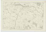
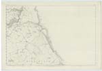
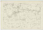
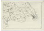
011 ; 012 ; 017 ; 018 | A parish in the eastern part of the Merse, Berwickshire. It is nearly a square form, 2½ miles deep; and is bounded on the North by Ayton; on the East by Mordington; on the South by Hutton; and on the West by Chirnside. The soil, in the south, is a strong clay; towards the middle of the parish it becomes more loamy; and in the N [North] is light and moorish. Excepting about 260 acres, chiefly in the centre of the district which are under Plantation, about 330 in the northern division, which are under natural pasture, all the area, comprising 3000 acres, has been turned up by the plough, and is in prime cultivation. The surface rises in a gently inclined plane from South to North, and terminates in a ridge of considerable heights. The uplands of the parish commands an excellent prospect to the South and East. Along its whole southern boundary runs the Whiteadder Water, between remarkably acclivitous banks, which climb from 120 to 150 feet above the level of the stream, and which, on the Foulden side, are repeatedly cloven by deep and wild ravines, bringing down rills and drainings from the central or northern districts. Near the upper end of two of these ravines or "dens" which deepen as they |
Continued entries/extra info
[Page] 1Parish of Foulden W. Beatty 1
Transcribers who have contributed to this page.
DANIALSAN, ron hill
Location information for this page.