OS1/5/14/5


| List of names as written | Various modes of spelling | Authorities for spelling | Situation | Description remarks |
|---|---|---|---|---|
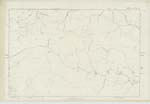
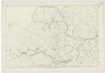
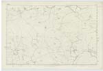
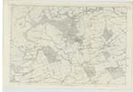
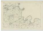
| LAMMERMOOR HILLS | Lammermoor Hills | Map of Berwickshire Fullertons Gazetteer Scotland New Statistical account of Berwickshire |
008 ; 009 ; 015 ; 016 | A broad range of Moorish heights, Stretching Eastward from the Vale of Gala Water, in the S.E [South East] extremity of Mid Lothian, to the German ocean at St. Abbs Head in the parish of Coldingham Berwickshire. The Lammermoors all lie within East Lothian, & Berwickshire, Commencing at their extreme Western limit, forming for two thirds of their extent a Southern Screen or belt of uplands to Mid Lothian; and Constituting - if the Lammermoor part of Lauderdale be included - nearly one half of Berwickshire. The Lammermoors, are, in themselves, an extensive Curvature of, for the most part, wild, cheerless, unsightly heights, nowhere bold and imposing in aspect, and often subsiding into low rolling Table-lands of bleak moor. They were at one period clothed with Forest, and must have been [continued on page 6] |
Continued entries/extra info
[Page] 5Cranshaws Parish (Detached) -- W. Beatty
Transcribers who have contributed to this page.
Trondragirl- Moderator, Moira L- Moderator
Location information for this page.
Linked mapsheets.