OS1/5/13/1


| List of names as written | Various modes of spelling | Authorities for spelling | Situation | Description remarks |
|---|---|---|---|---|
| CRANSHAWS (parish) | Cranshaws (Parish) | Map of Berwickshire Statistical acct. [account] Berwickshire Map of Scotland |
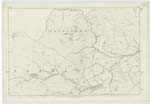
003 ; 009 | A parish at the middle of the Northern range of Berwickshire; but Consisting of two parts, the larger lying South of the smaller at the average distance of 1¼ Mile -- The northern part is bounded on the North and West by East Lothian, & on the East and South by the parish of Longformacus; and is of nearly a Square figure Measuring from Angle to Angle, both Southward & Westward about 2½ Miles --- On the North and East, round nearly one half of its limits, this Section has for its boundary line the Whiteadder Water - except in three instances ----- The Southern Section is bounded on the North & East by Longformacus, on the South by Westruther, on the West by Lauder & Longformacus; & is of an oblong form, Measuring 4½ Miles in extreme length -- & 2¼ in extreme breadth -- This Section has for its boundary line on the North, & partly on the East Dye Water; & it is traversed from West to East by the Watch Water - which, just when leaving it, falls into the Dye ---- |
Continued entries/extra info
[page] 1 Cranshaws Parish W. BeattyTranscribers who have contributed to this page.
Moira L- Moderator
Location information for this page.