OS1/5/7/1


| List of names as written | Various modes of spelling | Authorities for spelling | Situation | Description remarks |
|---|---|---|---|---|
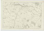
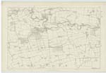
| CHIRNSIDE [parish] | Chirnside | Chalmers Caledonia Fullertons Gazeteer of Scotland New Statistical Acct [Account] Berwickshire Map of Berwickshire |
011 ; 017 | A parish in the county of Berwick, district of the Merse - It is bounded by Coldingham on the N [North] by Ayton and Foulden on the East, by Hutton & Edrom on the South, and by Bunkle on the West. The Whiteadder separates it from Edrom and Hutton parishes; and a deep ditch which has been executed for the purpose of draining Billymire Morass separates it from Bunkle and Coldingham - The extent of this parish is about 3½ by 3 miles - Among the several eminences which project from the Lammermoorhills into the low Country of Berwickshire, Chirnsidehill is a remarkable one - It is distinguished by its elevation and semicircular aspect to the South, joined with the great expansion of its summit and its gradual declination to the Whiteadder - It commands a view in Scotland - The landscape is that of a plain, waved with long ridges, running chiefly in one direction and of more than 25 miles in extent, from the bay of Berwick to the Teviotdale hills, on the West; while directly south, and at almost the same distance, the famed hills and chases of Cheviot form a very striking boundary - About 60 or 70 years ago says the writer of the old statistical account of 1794 - "this prospect, altho striking and noble, was a naked one, and had little or nothing of the beauty arising from extensive agriculture, enclosed fields or Plantations. If some groves or strips of trees marked, here and there, the seats of the gentry or nobles which |
Continued entries/extra info
[page] 1 Parish of Chirnside W BeattyTranscribers who have contributed to this page.
DANIALSAN, Moira L- Moderator
Location information for this page.