OS1/4/18/36


| List of names as written | Various modes of spelling | Authorities for spelling | Situation | Description remarks |
|---|---|---|---|---|
| CREAGAN A' CHÀISE | Creagan-a-Chaise Creagan-a-Chaise Creagan-a-Chaise |
Mr. Watson Inverlochy Mr. Watson Auchlichnie Mr. McLauchlan Dalbreac |
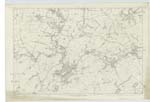
039 | A rocky eminence near the county boundary and near the southern extremity of the "Cromdale Hills". Meaning Little Cheese craig. |
| ALLT A' CHÀISE | Allt a' Chaise | Mr. Watson Inverlochy Mr. Watson Auchlichnie Mr. McLauchlan Dalbreac |
035 | A small mountain rivulet, rising on the east side of Creagan-a-Chaise: and running southward to "Allt Mor". |
| CROMDALE HILLS | Cromdale Hills Cromdale H. [Hills] Ben-Chromdal Beinn Chromdal Cromdale Hill |
Mr. Watson Inverlochy Mr. Watson Auchlichnie Mr. McLauchlan Dalbreac Robertson's Map of Banffshire &c 1822 Fullarton's Gazetteer Old Statistical Account Black's Map of Scotland |
029 ; 035 ; 039 | A range of high hills situated between Strathavon and Strathspey. The Water Shed along the Summit of the range is the boundary between the Cos. [Counties] of Banff and Elgin. The highest point of this range attains an elevation of about 2330 feet above the mean level of the sea. |
Continued entries/extra info
[Page] 36Co. [County] of Banff -- Ph. [Parish] of Kirkmichael & Inveravon
Transcribers who have contributed to this page.
Alison James- Moderator, HistoryHunter
Location information for this page.