OS1/3/63/21


| List of names as written | Various modes of spelling | Authorities for spelling | Situation | Description remarks |
|---|---|---|---|---|
| FAIRLIE ROADS | Fairlie Roads Fairlie Roads Fairlie Roads Fairley Roads |
Johnsons Map of Ayr Robert Hunter Esqr. George Muir [Cowdens Gazetteer] |
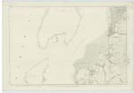
006 | This name is applicable to the navigable channel between the Island of Cambray and the low water mark of Southannan Sands extending from Hunterston Sands to near Largs, the name is popularly known. |
| SOUTHANNAN SANDS | Southannan Sands Southannan Sands Southannan Sands Sands of Southannan |
Robert Hunter Esqr. George Rae George Muir New Stat. Acct. [Statistical Account] |
006 | The Sands of Southannan extend in a northerly direction from near Hunterston Mill to the Parish Boundary between Largs & West Kilbride, these sands or beach include Fencebay |
| THE PERCH | The Perch The Perch The Perch |
Robert Hunter George Muir George Rae |
006 | A pole used as a beacon for the navigation of the Clyde it is about 20 feet high and the base is surrounded by stones large and small for the space of about 85 long and 80 broad, it is a well known object. |
Transcribers who have contributed to this page.
KatherineS, DANIALSAN
Location information for this page.
Linked mapsheets.