OS1/3/21/77


| List of names as written | Various modes of spelling | Authorities for spelling | Situation | Description remarks |
|---|---|---|---|---|
| MUCK WATER | Muck Water Muck Water Muck Water Muck Water Muck Water |
- A. Hervey W. Gilchrist W. G. Galloway Johnston's County Map |
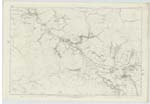
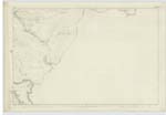
046 ; 053 | This is the largest Stream in the Parish, collecting and flowing from a marsh at the north base of Campbell Hill (adjacent to the County Boundary), in a westerly direction by Glenmuch [Glenmuck] House till it joins the Turnpike Road from Cairsphairn to Dalmellington, Keeping along this road through a deep wild glen in a northerly direction till it passes the village of Dalmellington, thence takes a westerly course till it joins the River Doon adjacent to and north of Auchenroy Bridge or Bogton Loch. It receives the next two largest Streams in the Parish viz Mossdale, and Cummock Burns, together with Several other minor and nameless ones in its course. It is Spaned by 7 Good Substantial Stone Bridges of one Arch each, 4 are on the Turnpike road from Ayr to Cairsphairn, 2 on Parish roads and one on a private road or avenue to Berbeth House, its whole course is Rapid with a rocky bed and broken banks After heavy Rains it rises to a degree Scarcely to be imgined . but it with all its branches collecting and flowing from the highest ground in the Parish will account for this. (Turn over) |
Continued entries/extra info
[Page] 77Dalmellington Parish-- Sheet 46 - 16. 12 & 2 52.4 and 53.1. 5 & 6
Transcriber's notes
Continues on page 78Transcribers who have contributed to this page.
Chr1smac -Moderator, hillhere
Location information for this page.