OS1/3/21/1


| List of names as written | Various modes of spelling | Authorities for spelling | Situation | Description remarks |
|---|---|---|---|---|
| DALMELLINGTON [parish] | Dalmellington Dalmellington Dalmellington Dalmellington Dalmellington |
Johnston's County Map Statistical Account (1842) Patterson's History of Ayrshire (1847) Wyllie's Ayrshire Streams County Voters' List |
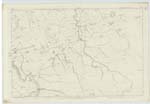
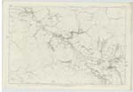
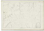
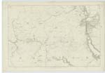
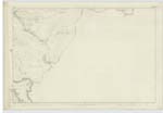
040 ; 046 ; 047 ; 052 ; 053 | The name of Dalmellington has been variously derived. In the first Statistical Acct [Account] and traditionally it is said to be corruption of Dame Helen's town "from a lady of rank of the name of Helen, who built a castle near the place." The parish of Dalmellington is about ten miles long and on an average fully three miles broad. It is seperated on the South & South West by the loch and river of Doon from the ph [parish] of Straiton, Dalrymple on the West Ochiltree on the North and New Cumnock and Carsphairn on the east. The only flat land in the ph [parish] extends from the village along the Doon Valley for about three miles, averaging 3/4 of a mile in breadth. There are several mountain passes in the ph [parish] of great depth and grandeur - the well-known "Craigs of Ness" is the deepest and wildest. There are two lochs in the ph [parish] - Loch Muick and Bogton Loch. The parish is chiefly pastoral the greater part of the land being incapable of profitable cultivation. Coal has been wrought in this ph [parish] and the field of that valuable commodity is understood to be extensive. Iron Works have been erected upon a large scale. Dalmellington is a place of some antiquity and though a mere village in point of size and population has long been a burgh of barony. [Continued] |
Continued entries/extra info
Parish of Dalmellington -- [Page] 1Transcribers who have contributed to this page.
Chr1smac -Moderator, Karen, Ann Houliston
Location information for this page.
Linked mapsheets.