OS1/3/10/115


| List of names as written | Various modes of spelling | Authorities for spelling | Situation | Description remarks |
|---|---|---|---|---|
| CLAUCHRIESKAIG | Claughrieskaig Claughrieskaig Claughrieskaig Claughrieskaig Clachraskaig |
Mr John McIlraith Revd. [Reverend] William Dill William McCulloch Esqr Mr H. Simpson Johnstons Co [County] Map |
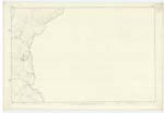
068 | [Situation] Situated in the N.N.W. [North North West] part of Plan, about 8 Chains NW [North West] of the River Cree. The Ruins of a Farm House near the county Bdy. [Boundary] the property of Messrs J McIlraith & John Lusk Esqr. |
| RIVER CREE | The Cree Cree Cree River Cree River Cree River Cree River Cree Water of Cree |
Fullarton's Gazetteer of Scotland 1842 Traveller's Guide through Scotland 1824 History of Ayrshire Bell's Geography 1847 J & G Walkers Map of Scotland Revd [Reverend] William Dill Mr McCulloch Esqr Johnstons Co. [County] Map |
063 ; 068 | [Situation] Flows in a South Westerly direction through the NE [North East] of the Plan. A River issuing from Loch Moan and emptying itself into the Sea at Wigton Bay, it constitutes the boundary between the Cos. [Counties] of Ayr , Wigton & Kirkcudbright. |
Continued entries/extra info
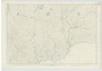
[page] 115Sheet 68 Plan 2 -- Trace 1, 2 & 4 -- Parish of Barr
Transcribers who have contributed to this page.
Chr1smac -Moderator, MarionQuinn
Location information for this page.