OS1/1/73/80


| List of names as written | Various modes of spelling | Authorities for spelling | Situation | Description remarks |
|---|---|---|---|---|
| FARMERS' LANE [Peterhead] | Farmers lane Farmers lane Farmers Lane |
Mr. D. Manson Peterhead Mr. James Brand Peterhead Plan of Peterhead 1805 by John Ainslie |
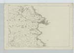
023 | Applies to a short street running from the corner of Union Street & Bridge Street to the South end of the North Harbour |
| BRIDGE STREET [Peterhead] | Bridge Street Bridge Street Bridge Street |
Mr. D. Manson Peterhead Mr. James Brand Peterhead Plan of Peterhead 1805 by John Ainslie |
023 | Applies to a street facing the North side of the South Harbour and extending from the corner of Farmers Lane & Harbour St. to its junction with Castle St. & Ship Row on the Keith Inch |
| JUNCTION CANAL | Junction Canal Junction Canal Junction Canal |
Mr. D. Manson Peterhead Mr. A. Souttar Peterhead Mr. James Brand Peterhead |
023 | Applies to a canal or cutting made in 1849 for the purpose of joining the North with the South Harbour and allowing Ships to pass through at high water into either harbour for the purpose of going to sea when the Wind is in a contrary direction for them when lying in either harbour, and having a very neat and substantial Iron Drawbridge across the Canal, for which ships have to pay toll when opened to allow them to pass through; about Mid Spring Tide the water is alternately as the tide ebbs & flows about 18 inches higher in the one harbour than in the other. |
Continued entries/extra info
[Page] 80Town of Peterhead
Transcribers who have contributed to this page.
GreenflyNZ, Serendipity
Location information for this page.
Linked mapsheets.