OS1/1/5/63


| List of names as written | Various modes of spelling | Authorities for spelling | Situation | Description remarks |
|---|---|---|---|---|
| RIVER DON | Don (The) The Don Don River River Don River Don River Don River Don River Don |
Fullarton's Gazetteer Old Statistical Account County Map New Statistical Account Guide to Donside Mr. Alexander Watt Mr. G. Cruikshank Mr. D. Christie |
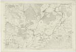
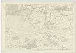
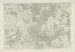
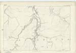
061 ; 062 ; 063 | A river in Aberdeenshire. It forms a sort of twin-stream to the Dee, and is next to that river in Aberdeenshire as regards at once basin, note, and magnitude and resembles it also in possessing much volume, and much fine scenery, with very little commercial importance; yet differs essentially from it in some great characters, and even presents some striking contrasts. It rises on the sKirts of Ben Avon, 6 miles west of Corgarff amongst the mountains which bound Aberdeenshire on the south-west, at the head of Strath Don, and which divide it from the head of Strath Deveron in Banffshire. Its source is considerably lower than that of the Dee; the altitude 1640 feet above sea-level. A great part of its run, though somewhat parallel to the Dee, and at no great distance from it, is through districts much less mountainous, and abounding far more in plains and expanded meadows; so that, instead of the impetuosity and the fitfulness of the Dee, it displays a prevailing gentleness (current of) Calmness, and regularity. Running eastward on a very sinuous career, through the whole breadth of the Country , it flows into the German Ocean on the north side of Aberdeen. Its whole length of course is about 62 miles, though in a direct line from its source to its termination, the distance is only 41 miles. In its earliest stretches through the parish of Strathdon, which it divides into two nearly equal parts, it is joined on both sides by 7 or 8 burns, separated from each other by considerable hills and most of them running through deep hollows and glens. The principal are the Ernan and the Nochtil. All these burns abound with most excellent trout; and salmon is even here very frequently found in the Don, at least towards the lower end of this Parish. Turning northward, and dividing for a short distance the parish of GlenbucKet from part of Migvie, it receives from the latter, the DesKry, and from the former the BucKet. Then flowing eastward, it passes through the parish Towie; and winding northward, reinforced by other tributaries around Gorrieshill, it at once becomes remarKably enlarged near Westside, after which it resumes its eastern route, dividing various parishes, particularly Forbes and Alford, from the latter of which it, on the south, derives the waters of the Lochel, the most considerable tributary it has yet received. In passing hitherto through the high parts of the district of Alford, The Don flows through a narrow gullet amongst the western mountains, while its banKs are now partly wooded. Perpetually changing its course to the north and even the west, to the east and then through Moneymusk parish, to the south, the next considerably tributary, which there enlarges it is the Ton Burn from the south; when immediately it turns to the north again between Kemnay and part of the Chapel Garioch Parishes, and arrives at a point a little to the south of the royal burgh of Inverury, where in its northern bank stands the building formerly occupied as the Roman Catholic college of Aquhorties. This point is about [Continued p 64] |
Continued entries/extra info
[Page] 63County of Aberdeen Parish of Alford
Transcribers who have contributed to this page.
Kate51- Moderator, M-R
Location information for this page.