
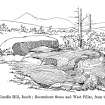
Candle Hill


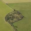
Oblique aerial view of Candle Hill recumbent stone circle, taken from the S.
View in Canmore
View in Canmore

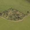
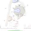
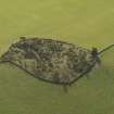
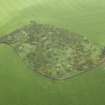
Detailed oblique aerial view centred on the remains of the recumbent stone circle, taken from the N.
View in Canmore
View in Canmore

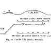
Section drawing of recumbent stone circle
View in Canmore
View in Canmore

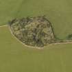
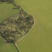
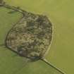
Oblique aerial view of Candle Hill recumbent stone circle, taken from the N.
View in Canmore
View in Canmore

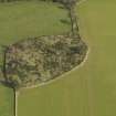
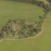
Oblique aerial view of Candle Hill recumbent stone circle, taken from the WNW.
View in Canmore
View in Canmore

Oblique aerial view of Candle Hill recumbent stone circle, taken from the SSW.
View in Canmore
View in Canmore

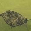
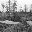
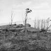
Recumbent stone and fallen pillar.
Original negative captioned 'Part of Stone Circle (Altar Stone) (fallen) Candlestone Hill near Insch September 1901'.
View in Canmore
View in Canmore

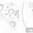
RCAHMS survey drawing: Plan and elevation of Candle Hill Stone Circle
View in Canmore
View in Canmore

RCAHMS publication drawing: plan of Candlehill recumbent stone circle
View in Canmore
View in Canmore

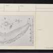
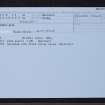
Candle Hill, NJ52NE 10, Ordnance Survey index card, Verso
View in Canmore
View in Canmore

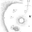
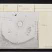
Sketch view of recumbent stone circle
View in Canmore
View in Canmore

Oblique aerial view of Candle Hill recumbent stone circle, taken from the SE.
View in Canmore
View in Canmore

Candle Hill, NJ52NE 10, Ordnance Survey index card, page number 2, Verso
View in Canmore
View in Canmore

Photograph of recumbent stone circle at Candle Hill, Insch, taken S.
Titled: "Candle Hill, Insch. Recumbent Stone and fallen Flankers".
View in Canmore
View in Canmore

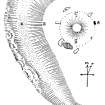
Candle Hill, Old Rayne; Plan (PSAS 36, 1901-1902, fig 44, p541)
View in Canmore
View in Canmore

Candle Hill; Plan of the Circle (PSAS 36, 1901-1902, fig 59, p542)
View in Canmore
View in Canmore

Candle Hill, NJ52NE 10, Ordnance Survey index card, Recto
View in Canmore
View in Canmore

Oblique aerial view of Candle Hill recumbent stone circle, taken from the NE.
View in Canmore
View in Canmore

Oblique aerial view of Candle Hill recumbent stone circle, taken from the NNW.
View in Canmore
View in Canmore

Oblique aerial view of Candle Hill recumbent stone circle, taken from the W.
View in Canmore
View in Canmore

Oblique aerial view of Candle Hill recumbent stone circle, taken from the SW.
View in Canmore
View in Canmore

Candle Hill, NJ52NE 10, Ordnance Survey index card, page number 1, Recto
View in Canmore
View in Canmore

Candle Hill, NJ52NE 10, Ordnance Survey index card, Recto
View in Canmore
View in Canmore

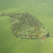
Detailed oblique aerial view centred on the remains of the recumbent stone circle, taken from the NNE.
View in Canmore
View in Canmore

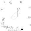
Candle Hill, Insch; General Plan of the Site (PSAS 36, 1901-1902, fig 58, p541)
View in Canmore
View in Canmore

Candle Hill, NJ52NE 10, Ordnance Survey index card, Recto
View in Canmore
View in Canmore
You may copy, display, store and make derivative works for personal use or use solely within an educational institution by staff and students, under these conditions: the ScotlandsPlaces website is attributed, there is no commercial use or sale, and no public distribution (for example, by hand, email, or web). Full licence details.
Details
Organisation: Historic Environment Scotland (HES)
Alternative name(s): Candlehill; Candle Stane; Coldhome
Canmore ID: 17615
Site type: Cup Marked Stone (prehistoric), Recumbent Stone Circle (neolithic) - (bronze Age), Roundhouse (prehistoric)
County: Aberdeenshire
Parish: Insch
Council: Aberdeenshire