OS1/18/4/125


| List of names as written | Various modes of spelling | Authorities for spelling | Situation | Description remarks |
|---|---|---|---|---|
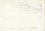
| RUDHA NAN TOTAG | Rudha nan Totag Rudha nan Totag Rudha nan Totag |
John McKinnon, Taransay Admiralty Chart AA Carmichael Esq |
009 | The most northerly point on the coast of Taransay. It is situate directly north form Ben Raah. Sig. [Signifies] Point of the ruins. |
| GEO AN TAIRBH | Geo an Tairbh Geo an Tairbh Geo an Tairbh |
John McKinnon, Taransay Admiralty Chart AA Carmichael Esq | 009 | A small creek 18 chains from the above named point. It signifies the Bulls Creek. |
| GEO A' MHAIDE | Geo a' Mhaide Geo a' Mhaide |
John McKinnon, Taransay Admiralty Chart | 009 | A small creek on the west side of Ru nan Totag. Signifies Stick Creek. |
Continued entries/extra info
[Page] 125Hebrides, Parish of Harris
County of Inverness
Correction of "Ru" to "Rudha" 4.2.78 [initials]
Transcribers who have contributed to this page.
MargieO
Location information for this page.