OS1/5/4/86


| List of names as written | Various modes of spelling | Authorities for spelling | Situation | Description remarks |
|---|---|---|---|---|
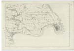
| WHITEADDER WATER | Whiteadder Water | Map of Berwickshire Rev. [Reverend] Thomas Davison Abbey St. Bathans Peter Donaldson Ellenford |
018 | A river, or as it is termed water, which takes its rise in the Lammermoor Hills in Haddington Shire at a place called Whitewells, and flowing in a S. [South] Easterly direction empties itself into the Tweed a little S.W. [South West] of the town of Berwick upon Tweed - This river or water takes its rise in one of the wildest districts in the South of Scotland, in its course passes through varied scenery - sometimes through flat Haughs, but (in the Lammermoors) through places where the Hills close in, so as to narrow the valley almost to the bed of the river. At Preston Mill & Haugh, the river escapes from the wild, rocky Mountainous Country, entering the beautiful valley in which the Tweed runs - the richest fields succeed the barren waste - woodlands, orchards and highly cultivated grounds bespeak wealth and comfort. The river itself partakes of the character of the country - running in gentle streams over Pebbly beds, alternating with long reaches of still water. A Burnaby Capt. R.E. [Captain Royal Engineers] 31 March 1852 |
Continued entries/extra info
[Page] 86 Liberties of BerwickTranscribers who have contributed to this page.
DANIALSAN, Alan White
Location information for this page.
Linked mapsheets.